Everything You Need to Know About Puerto Rico
All the essential information you need to plan your trip to this Caribbean paradise. You can also read our travel guide to help with trip planning.
The Island
Puerto Rico is an archipelago situated between the Caribbean Sea and the Atlantic Ocean. It’s located about 1,600km (1,000 miles) southeast of Miami, Florida, and roughly 112km (70 miles) east of the Dominican Republic. Puerto Rico is often referred to as the Island of Enchantment, and it’s a fitting description. Idyllic beaches, verdant mountains, a tropical rainforest and countless other lures make Puerto Rico a favorite getaway for millions of people each year.

Getting There
Each month there are more than 4,500 direct flights to San Juan. About 2,600 of them arrive from the U.S. San Juan is also one of the world’s busiest cruise ship ports, welcoming nearly 2 million cruise passengers each year.
Travel Documents
Puerto Rico is a commonwealth nation of the United States. U.S. citizens aren’t required to go through customs. They also don’t need a passport on arrival or for their return trip.
Language
The two official languages of Puerto Rico are Spanish and English. Road signs are written in Spanish. However, you don’t need to be bilingual to visit, as English is widely spoken here in most regions. It’s good to know a few basic words and phrases, just in case.
Currency
The currency in Puerto Rico is the U.S. dollar. Major credit cards are accepted and ATMs are easy to locate.
Time Zone
Puerto Rico observes the Atlantic Time Zone (which aligns with Eastern Standard Time in the U.S.). Puerto Rico doesn’t observe daylight saving time.
Weights and Measures
Puerto Rico largely follows the American imperial system. However, road signs are marked in kilometers and gas is pumped in liters.
Climate
The year-round temperatures in Puerto Rico vary between 75 and 85 degrees Fahrenheit (24 and 29 degrees Celsius). It’s cooler during the high season (from December to April). The hottest month is typically the peak of August when the average high temperature can reach 89 degrees Fahrenheit. Temperatures in the northern and central regions of Puerto Rico are generally cooler than the south by a few degrees. Temperatures in the higher elevations average between 61 degrees Fahrenheit and 80 degrees Fahrenheit. The average annual rainfall is 1422.4mm (56 inches).
Population
Roughly 3.2 million people call the island territory of Puerto Rico home. Almost 400,000 of them reside in the capital city of San Juan.
Regions
Puerto Rico comprises six regions. They are:
- North (includes Arecibo, Barceloneta, Camuy, Dorado and Florida)
- Metro (includes San Juan and Carolina)
- East (includes Culebra, Fajardo, Ceiba, Luquillo and Vieques)
- Central (includes Aguas Buenas, Aibonito, Bayamón and Orocovis)
- South (includes Ponce, Arroyo, Guayama and Santa Isabel)
- West (Aguadilla, Cabo Rojo, Guánica, Rincón and San Germán)
Topography
Though it’s only 9,104 sq. km (3,515 sq. miles), Puerto Rico teems with sun-kissed beaches, lush mountains, an extensive cave system and the only rainforest within the U.S. Forest System.
There are 300 public beaches that are managed by the Puerto Rico National Parks Company. This means you’ll find restroom facilities, lifeguards, chair rentals and other conveniences needed for a day at the beach. Puerto Rico’s northern and central regions boast a significant network of more than 220 subterranean caves. One of them, Río Camuy Cave, is the largest cave network in the Western Hemisphere. Spanning almost 29,000 acres, El Yunque National Rainforest is located on the slopes of the Sierra de Luquillo mountains.
The National Flag
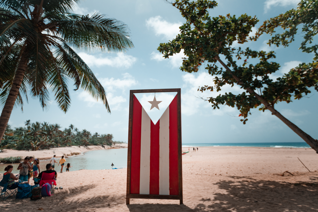
The National Flag of Puerto Rico was officially adopted in 1952. The flag’s red stripes symbolize the bloodshed during Puerto Rico’s fight for independence. Peace and victory are represented in the flag’s two white stripes. The white star represents the island of Puerto Rico and the blue color surrounding it stands for the sky and ocean. Puerto Rico’s flag is the same as Cuba’s, but with inverted colors. They were designed the same year by exiled citizens of Puerto Rico and Cuba living in New York City.
A Brief History
Earlier groups like the Arawak, Saladoid and Ortoiroid inhabited the island perhaps as early as 4,000 B.C. However, ancestors of the native Taíno population of Puerto Rico arrived on the island between 500 B.C. and 200 B.C., well before Christopher Columbus claimed the island for Spain in 1493. Columbus named the island San Juan Bautista to honor Saint John the Baptist.
Juan Ponce De León established the first permanent Spanish settlement in 1508. Located on the island’s northern coast, the settlement was originally named Caparra. It was renamed Puerto Rico (rich port) 13 years later due to the abundant gold settlers found on the island. Over the years, the island’s name evolved into Puerto Rico and the port city became known as San Juan.
After the Spanish-American War of 1898 ended, Spain ceded Puerto Rico to the U.S. under the Treaty of Paris. In 1948, U.S. Congress passed an act allowing Puerto Ricans to elect their own governor. Puerto Rico officially became a U.S. Commonwealth in 1952.
Other interesting facts
- There are only five bioluminescent bays in the world. Three of them are located in Puerto Rico—Mosquito Bay in Vieques, Laguna Grande in Fajardo and La Parguera in Lajas.
- Puerto Rico is home to two of the oldest churches in the Americas—Church of San José and San Juan Cathedral.
- The legal drinking age here is 18 (proof of age required).
- The coquí frog is only found in Puerto Rico. It’s the country’s unofficial symbol.
- Barceloneta, in Puerto Rico’s northern region, is known as “Pineapple City” because of the large amount of pineapple plantations located there. Barceloneta is also known for its blue sand beaches.
- There are no snakes, bears or any dangerous animals within El Yunque National Forest


